Bretonnianadvisor: Finisterre
Click here- Cape Finisterre video
Showing posts with label GEOGRAPHY. Show all posts
Showing posts with label GEOGRAPHY. Show all posts
Thursday, 1 June 2017

Monday, 17 April 2017
Sunday, 19 March 2017
Agricultural Landscape- Geography

This is the agricultural landscape that I have choosen. It is from Near Cognac, in France:
- It has got open fields, beacause there aren't any boundaries wich separe plots.
- It is a polyculture landscape, because there are two types of plots.
- I think it's type of farming is irrigated, because there aren't any irrigation systems.
- It is an extensive agriculture, because there is a lot of land.
Sunday, 5 March 2017
Geography Glossary- The State
-State: territory, province.
-Inhabitants: person: resident.
-Boundaries: limit of land, property.
-Currency:money system.
-National anthem: official song of a country.
-Laws: rules, government laws.
-Taxes: a sum of money demanded by a government for its support or forspecific facilities or services, levied upon incomes, property, sales, etc.
-State: territory, province.
-Inhabitants: person: resident.
-Boundaries: limit of land, property.
-Currency:money system.
-National anthem: official song of a country.
-Laws: rules, government laws.
-Taxes: a sum of money demanded by a government for its support or forspecific facilities or services, levied upon incomes, property, sales, etc.
-Population: inhabitants.
-Foreigners: a person from outside one's community.
-Citizens: member of a country.
-Freedom asociation: right to affiliate(libertad de afiliacion).
-Free spech: it is free to give your opinion (libertad de expresion).
-Rights: the rights to full legal, social, and economic equality extended to blacks.
-Fine: (multa)
-Politics: directing states or cities (políticas).
-Worldwide: spanning the world.
-Civil servants: government employee(funcionario).
-Country: political geographic area.
-Foreigners: a person from outside one's community.
-Citizens: member of a country.
-Freedom asociation: right to affiliate(libertad de afiliacion).
-Free spech: it is free to give your opinion (libertad de expresion).
-Rights: the rights to full legal, social, and economic equality extended to blacks.
-Fine: (multa)
-Politics: directing states or cities (políticas).
-Worldwide: spanning the world.
-Civil servants: government employee(funcionario).
-Country: political geographic area.
Thursday, 23 February 2017
Kenya's project
-This project about Kenya was made by Elia Calvo, Paula Merino, and me:
https://drive.google.com/open?id=0BwZWmaNvcCzvN2FNUDVLbjY4R2M

-This project about Kenya was made by Elia Calvo, Paula Merino, and me:
https://drive.google.com/open?id=0BwZWmaNvcCzvN2FNUDVLbjY4R2M
Sunday, 15 January 2017
Geography-Africa video
ANSWER THE FOLLOWING QUESTIONS
1. Where in the world is Africa ?
2. How many times is Africa larger than The United States?
3. How is the savanna defined in the video?
4. Which animals can be found in the savanna biome?
5. Where is located the chaparral biome in Africa ?
6. Which are the most famous deserts in Africa ?
7. The main natural resources mentioned in the video are ....
1. Africa is located at the South of Europe and at the Southwest of Asia.
2. Africa is three times the size of The United States.
3. The savanna biome is defined in the video as a grassy plain which covers nearly half of Africa.It's characterized by scattered trees among a landscape of grasses and shrubs.
4. The most common animals that can be found in the savanna biome are elephants and giraffes.
5. The chaparral biome is located at northern coast of Africa and along the Mediterranean coast and there is also in the south of Africa as well.
6. The most famous deserts in Africa are the Sahara desert, the Namib desert and the Kalahari desert .
7. The main natural resources mentioned in the video are gold mines,rober trees and oil.
FIND THE MISSING WORDS
1. Africa runs 5 000 miles from the Mediterranean sea all the way
down to
the Cape of Good Hope and 4 600 miles from Cape
Verde all the way over to Senegal.
2. Biomes are climate zones and throughout that area, throughout that
climate zones , you can see the same average temperature and average precipitations what
that means is that you also see very similar vegetation and fauna living
in that region.
3. The most famous desert in Africa is, of course,
the Sahara desert. Now, some parts of the Sahara desert
are sandy, like you can see here. Other
parts of the Sahara desert are rocky but in
either case, the fact that it is very dry is
going to make it a very difficult period to cross.
4. It is not the rain itself that’s
particularly important, it’s also the environment diversity.There
are many different fauna and vegetation. That can be
found in the rain forest and that’s one of
the thing that makes the rain forest so valuable not just
in Africa but throughout the Earth.
5. The Nile is the most famous river in Africa, because is the largest river in the world. But there is also
the Congo river which is the second longest river
in the world.
6. Africa actually has its own version of the Great Lakes with famous lakes
like Lake Kivu,lake Malawi,lake Victoria and lake Tanganyika.
7. All the Africa is a plateau. Meaning
that Africa itself is an elevated land.
But that doesn’t mean that you can’t find any mountain ranges like, for
example, the Atlas mountains in
northwestern Africa.
8. Africa also has some interesting mountains like Kilimanjaro mountain , the highest mountain in Africa which seems to
just rise on it own out of the ground.
9. The Great Rift Valley refers to a region of Africa that is
literally, being split apart. There are
some tectonic plates that are located within or near
Africa, that are, actually moving away from
each other, and what’s doing is creating not just some of the highest elevations in Africa, but also lakes like Tanganyika that is among the deepest in the world.
Tuesday, 13 December 2016
Geography glossary- Population
|
-Birth rate: total number of live births per 1000 of a
population in a year.
|
|
-Death rate: (mortality rate) measure of the number of
deaths that take plas in a population over a year.
|
|
-Natural increase: number
of births minus the number of deaths.
|
|
-Infant mortality rate: number
of deaths of infants under one year divided with the number of deaths in a
year, per 1000.
|
|
-Life expectancy: average
years that one person may expect to live.
|
|
-Birth control: method
or devise used to prevent pregnacy.
|
|
-Dependent population: part
of the population that does not work and relies on others for the services
they consume.
|
|
-Dependency ratio: age
population ratio of thos tipically not in the labor force.
|
|
-Family planning:practise of controlling the
number of children in a family and the intervals between their births.
|
|
-Population piramids/age-gender structures: diagrams
that decipt the distribution of the population at a particular time and
location.
|
|
-Replacement rate
|
|
-Fertility rate: number
of children that would de born to a woman over a lifetime.
|
|
-Ageing population: in
developed countries, the number of young people is smallest than the number
of old people.
|
|
-Population distribution and population density
|
|
-A more economically developed country (MEDC) and less
economically developed country (LEDC)
|
|
-Overpopulation and under population
|
Wednesday, 16 November 2016
School trip to Valladolid
Some days ago, we went to Valladolid, and Peñafiel. First, we went to Valladolid. When we arrived, we visited the centre of the city, and we had some free time.Then, we went to the "Miguel Delibes", a theatre in wich we saw a concert of contemporaean music. When we finished, we had lunch and we had a really great time. One hour later, we travelled to the Peñafiel´s castle. First, we went to a wine museum, and then, we visited the castle. In my oppinion, it was a really intestering excursion, and we had a great time!


Sunday, 30 October 2016
Project about a landscape- Iceland


-Location:
This place is located in Iceland. It's a Nordic Island Country, located in the northwest of Europe, in the Atlantic sea.


-Climate:
 |
| Glaciar Eyjafjallajökull |
The climate is known as subpolar oceanic. It has got cool and brief summers,and soft winters, with temperatures that don't raise more than -3ºC. The warm North Atlantic Current ensures generally higher annual temperatures than in most places of similar latitude in the world.
-Vegetation:
Approximately three quarters of the island are barren of vegetation; plant life consists mainly of grassland, which is regularly grazed by livestock. The most common tree is the northern birch, which formed forests over much of Iceland, along with aspens,common junipers and other smaller trees. |
| Juniper |
 |
| Northern birch |

Aspens
-Fauna:
The animals of Iceland include the Icelandic sheep, cattle, chickens, goats, the sturdy Icelandic horse, and the Icelandic Sheepdog.Wild mammals include the Arctic fox, mink, mice, rats, rabbits and reindeer. Many species of fish live in the ocean waters surrounding Iceland. |
| Icelandic Sheepdog |
 |
| Icelandic Sheep |
 |
| Icelandic horse |
 |
| Mink |
 |
| Artic Fox |
Tuesday, 18 October 2016
Social science glossary-
Climate and bioegraphy (Europe and Spain)
Climate and bioegraphy (Europe and Spain)
-Europe maritime (oceanic) and mediterrean climate vocabulary
 |
| Oak (roble) |
 |
Shrubs/bush (arbustos)
|
 |
Beeches (haya)
|
 |
| Clear forest (bosque hueco) |
 |
Cork oak (alcornoque)
|
 |
| Deer (gamo/ciervo pequeño) |
 |
| Thikets (matorral) |
 |
| Water birds (aves acuáticas) |
 |
| Holm oak (encina) |
 |
| Lynx (lince) |
 |
| Stork (cigueña) |
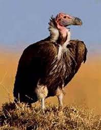 |
| Vulture (buitre) |
 |
| Meadow (prado) |
Wednesday, 12 October 2016
Social science glossary-
Land and coastal relief II
-Basin= area of land containing a river or a lake that is lower than the sourronded area (depresión)
-Peninsula= a piece of land sourronded by water in all sides except one
-Island= piece of land completly sourronded by water
-Archipelago= group of islands
-Livestock= farm animals (ganago, ganadería)
-Cattle= cows
-Ridge= mountain range
-Buttes= hill or mound (cerro)
-Mesas= plateau
-Greek= stream
-Flood plain
-Brine= water that you can't drink (no potable)

Land and coastal relief II
-Basin= area of land containing a river or a lake that is lower than the sourronded area (depresión)
-Peninsula= a piece of land sourronded by water in all sides except one
-Island= piece of land completly sourronded by water
-Archipelago= group of islands
-Livestock= farm animals (ganago, ganadería)
-Cattle= cows
-Ridge= mountain range
-Buttes= hill or mound (cerro)
-Mesas= plateau
-Greek= stream
-Flood plain
-Brine= water that you can't drink (no potable)
 |
| Ridge |
 |
| Butte |
Cattle
Monday, 10 October 2016
Social Science Glossary-
Land and coast relief I
-Ravine= steep gorge (barranco)
-Steep= sharply sloped (empinado)
-Slope= angle of mountain (ladera)
-Gorge= ravine (barranco/garganta)
-Plateau= an elevated, comparatively level expanse of land (meseta)
-Sligthly= to a small degree (ligeramente)
-Plains= flat land (llanura)
-Debris= remains (sedimentos)
-Estuary= where a river meets the sea (estuario)
-Gulf= body of water (golfo)
-Cape= a point or head of land projecting into a body of water
-Cliff= steep rock face (acantilado)
Land and coast relief I
-Ravine= steep gorge (barranco)
-Steep= sharply sloped (empinado)
-Slope= angle of mountain (ladera)
-Gorge= ravine (barranco/garganta)
-Plateau= an elevated, comparatively level expanse of land (meseta)
-Sligthly= to a small degree (ligeramente)
-Plains= flat land (llanura)
-Debris= remains (sedimentos)
-Estuary= where a river meets the sea (estuario)
-Gulf= body of water (golfo)
-Cape= a point or head of land projecting into a body of water
-Cliff= steep rock face (acantilado)
 |
| Gorge |
 |
| Ravine |
 |
| Plains |
 |
| Plateau |
Sunday, 2 October 2016
Social Science Glossary-First week
-Grassland: grassy land (pradera)
-Coast: land by the sea
-Natural resources
-Wild pig: animal similiar to a pig (jabalí)
-Grasshoper: insect (saltamontes)
-Fire insurance
-Rainfall: measure of rain (precipitación)
-Streams: small river (riachuelo)
-Temperate: mild weather (templado)
-Dam:water barrier (presa)
-Due to: debido a
-Made up: hacer algo
-Contours: outline of a shape (contorno)
-Mountain range:series of mountains (cordillera)
-Hill
-Oasis: water in desert
-Archipelago: group of islands
-Flood: water (riada, inundación)
-Earthquake: seismic tremor (terremoto)
-Volcano
-Grassland: grassy land (pradera)
-Coast: land by the sea
-Natural resources
-Wild pig: animal similiar to a pig (jabalí)
-Grasshoper: insect (saltamontes)
-Fire insurance
-Rainfall: measure of rain (precipitación)
-Streams: small river (riachuelo)
-Temperate: mild weather (templado)
-Dam:water barrier (presa)
-Due to: debido a
-Made up: hacer algo
-Contours: outline of a shape (contorno)
-Mountain range:series of mountains (cordillera)
-Hill
-Oasis: water in desert
-Archipelago: group of islands
-Earthquake: seismic tremor (terremoto)
-Volcano
 |
| Dam |
 |
| Grasshoper |
Subscribe to:
Posts (Atom)